


La Tour d'Aigues

phugues
User
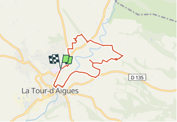

Length
7.1 km

Max alt
319 m

Uphill gradient
127 m
Km-Effort
8.8 km

Min alt
247 m

Downhill gradient
123 m
Boucle
Yes
Creation date :
2022-08-21 19:36:45.875
Updated on :
2022-08-21 19:37:16.14
2h00
Difficulty : Medium

FREE GPS app for hiking
 SityTrail
IGN / Geographical institutes
SityTrail Plus
The world is yours!
About
Trail Walking of 7.1 km to be discovered at Provence-Alpes-Côte d'Azur, Vaucluse, La Tour-d'Aigues. This trail is proposed by phugues.
Positioning
Country:
France
Region :
Provence-Alpes-Côte d'Azur
Department/Province :
Vaucluse
Municipality :
La Tour-d'Aigues
Location:
Unknown
Start:(Dec)
Start:(UTM)
705486 ; 4845040 (31T) N.
Comments